Putting it all together
Yesterday’s hike was a test of all the skills and conditioning we’ve been working on over the past few months. The trip to Nambe Lake.
A couple months ago, Michelle asked me, “have you ever been to a mountain lake? Because I’d really like to see that.” We did some research and found three possible hikes in the area: Nambe Lake, Spirit Lake, and Stewart Lake. Every one of them more challenging than anything we’ve done up to this point. It was going to take some work.
For the last several weeks, we’ve been taking hikes to add different elements we would need to pull this off. Adding distance, greater ascents, higher elevations, and more technical aspects like water crossings and scrambling. This was no stroll in the woods. We decided this weekend was the time to try for the lake.
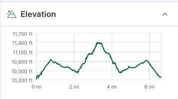
This hike is no joke and not for newbies. It starts above 10,000 feet and tops out at just over 11,400. And that last mile is steep. See for yourself.
Hiking is a big pastime here. Most trails, you see groups of very-fit-but-senior hikers out doing their thing, along with families and folks of all sorts. This trail, almost everyone we saw was an athletic twenty-something. In retrospect, I should have paid more attention to that.
We knew we were going to need some extra fuel for this one, so Michelle picked out some muffins and some pasta salad to augment our usual hiking rations. Let me just say, the pasta salad was a master stroke that charged us up both physically and emotionally.
You start off on part of the Winsor trail at Ski Santa Fe. It’s a very popular trail that runs 24 miles from Tesuque Village clear over the mountains to Cowles. We’ve hiked many parts of that trail before, but never this section. The first 1/2 mile is - we’ll call it a ‘bracing’ climb up to the Raven’s Ridge intersection and then you cross into the Pecos Wilderness. The next mile or so is a nice, gentle downhill through the forest. Easy peasy. Then you turn off onto the Nambe Lake Trail (#400) and things get… serious.
It’s not much of a ‘trail’ for much of it. You can follow the Rio Nambe to get to the lake, but you’ll add a lot of extra distance and have to backtrack more than once. You really need a GPS to stay on track. But if you don’t have one, my advice would be “just pick the steepest, rockiest section above you and that’s probably right.”
Up above 11,000, the temperature dropped significantly and we had to layer up, despite the exertion of the climb. Then, about 1/8 mile from the top, both of us hit a bit of a wall. Looking back across the steep, rocky terrain below us and the still-steep-but-covered-with-3-foot-snowdrifts above us, I’ll admit I was seriously re-thinking my choices. If it weren’t for the encouraging words of a couple heading back down, “you’re almost there!” I might have turned back.
But the payoff. Well, see for yourself.
Nambe Lake
So - six hours, seven miles, 1,700 feet of elevation gain, rocky terrain, water crossings, post holing in snow drifts, sore ankles, scratches and bruises… was it worth it?
Yeah. It totally was. Check out the rest of the Nambe Lake gallery here.


